Wouldn’t it be nice to know at the beginning of the summer how bad blue-green algae blooms were going to be on Lake Champlain? Well, researchers from the National Oceanic and Atmospheric Administration’s National Center for Coastal Sciences (NCCOS) believe they have developed a model that can make such predictions for Lake Erie. In 2012 they issued their first seasonal harmful algae bloom forecast, predicting mild blooms during the summer. MORE Read...
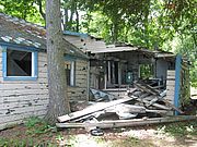
Law Island is an 8.5 acre island close to the breakwater in Malletts Bay. A site on the Lake Champlain Paddlers’ Trail, it provides a secluded setting in a high traffic area of Lake Champlain with outstanding views of the lake and several islands. For years, five dilapidated buildings contaminated with lead and asbestos and several junk cars have marred its beauty and posed environmental and liability concerns. MORE Read...
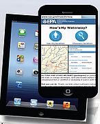
Earlier this month the U.S. Environmental Protection Agency (EPA) launched a new app and website to help people find information on the condition of thousands of lakes, rivers and streams across the United States from their smart phone, tablet or desktop computer. MORE Read...
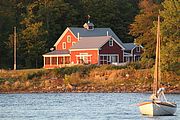
Members and friends gathered at “The Barnhouse” in historic Isle La Motte earlier this month for LCC’s 49th Annual Meeting. Attendees learned about current work, got a status report on lake health, conversed with other lake lovers, ate great food, and toured or paddled the area. MORE Read...
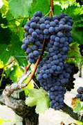
A new international wine trail was unveiled at Snow Farm Vineyards in South Hero, Vermont in late September. Linking many wineries extending from Middlebury, Vermont, to Plattsburgh, New York and to Dunham, Québec, the Champlain Valley International Wine Trail will provide information to casual travelers and wine aficionados alike. MORE Read...
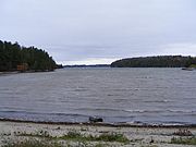
Strong winds out of the north during Hurricane Sandy led to a decrease in lake level at Rouses Point and an increase at Whitehall as waters were pushed south. The difference amounted to about four inches. Following the storm, the lake leveled out again. The effect was less extreme than what was seen during Tropical Storm Irene when nearly a foot of water was displaced. MORE Read...
Members are the lifeblood of LCC. Annual membership helps fund our work to protect and restore water quality, safeguard natural habitats, provide access, and educate and engage people in stewarding this beautiful waterbody. Our deep thanks to LCC members who renewed their membership or joined during July through September 2012. MORE Read...
Two recent proposals have shown that Lake Champlain is likely to be in the center of our region’s future energy transmission network. One project proposes to lay a power line at the bottom of Lake Champlain to transmit energy from large hydro-electric dams in northern Quebec to power-hungry consumers in the New York City region. MORE Read...
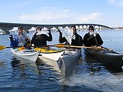
Join veteran kayaking instructor and Kokatat representative Suzanne Hutchinson for a cold water immersion clinic. The day-long program includes both inside instruction about the dangers of cold water paddling and how to prepare along with an outdoor portion on the water. Participants will learn about appropriate dress and skills for paddling in cold conditions. MORE Read...