Lake Flooding - What's it Mean?
May 2011
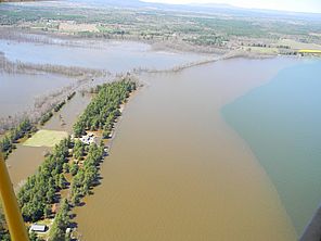
Lake Champlain reached new heights this spring, cresting at 103.2' on Friday, May 6th, shattering the previous record high level from May of 1869 (~102.1’). At the flood maximum an added 867 billion gallons of water increased the area of the lake by 15%. High water inundated homes, displaced people, closed roads, triggered mudslides, and washed sewage, litter and debris into the lake. Tons of sediment flowed into Lake Champlain as wind, waves and high water eroded stream banks and lakeshore. The Lake Champlain Ferry from Essex to Charlotte closed because the landing is under water. Amtrak service from Montreal to Schenectady, NY was interrupted. Traffic along the Route 2 causeway between Grand Isle and Colchester was reduced to one lane as work crews repaired damage. Both Governors Cuomo and Shumlin declared states of emergency for portions of the lake shore, expecting damages in the millions of dollars. The Canadian Forces were called out to assist in flooded areas north of the border. Flooding has also been severe along the Richelieu River, downstream of Lake Champlain.
The level of Lake Champlain is essentially unregulated. Discharge from Lake Champlain is controlled by a sill of compacted glacial till near St. Jean Quebec. Fryers Dam, the first dam encountered after leaving Lake Champlain, sits downstream of this sill. Changes in the Chambly canal system in the early 1970’s increased lake levels up to 0.5’ during high water events.
In 1973 the International Joint Commission (IJC) debated whether to regulate the level of the Richelieu River and Lake Champlain to address shoreline flooding in Quebec. An IJC-appointed engineering board agreed that regulating water levels could reduce flood damage, but they disagreed on the environmental affects that would occur. The IJC continued their investigation until January of 1981. The Lake Champlain Committee, with the support of Dr. Stockton Barnett of PSUNY and other scientists compiled extensive evidence that artificially manipulating lake levels would have costly economic and environmental impacts. Ultimately the IJC opted against regulating water levels, and instead recommended improved flood forecasting and a variety of non-structural measures to lessen flood damage. In the current flooding we see damage both upstream and downstream of Lake Champlain’s grade control, suggesting lake level regulation would not alleviate impacts of high water events.
High lake levels were brought about by extreme wet weather. Snow pack in the mountains accounted for the greater part of increased flows. Continued wet weather delayed a return to more typical lake levels. By mid-May the spring of 2011 had already become the wettest on record.
The high precipitation levels this winter and spring that led to flooding continue a pattern that has been seen over the last few decades. Total annual precipitation between 1976 and 2005 was approximately three inches greater on average than it had been in the preceding eight decades according to a report on climate change impacts from The Nature Conservancy (TNC). It certainly has not gotten drier since 2005. The TNC report concludes “The basin could receive as much as 10-15% (ca. 4-6 inches) more precipitation in an average year, with heavy storms events becoming more frequent.”
Phosphorus loading for 2011 will be substantially higher than normal due to the flooding. High waters, particularly in tributaries, increase erosion and transport of phosphorus pollution to Lake Champlain. During the last week of April, the Winooski River carried half its usual annual load of phosphorus. On a single day, April 26th, the Winooski’s phosphorus discharge was two times the annual discharge of all Vermont wastewater plants combined. Most phosphorus entering the lake during the spring arrives attached to soil particles that move with high flows. Wind and wave action erode shorelines that are normally above the high water mark, resulting in extensive soil erosion, transport and lake deposition. Flooded tributaries running over farm fields that have not yet been planted are causing even more erosion. Sediment loading to the lake from this event could be unprecedented in recorded history.
In addition to erosion, pollution has entered the lake from wastewater treatment facility overflows caused by high waters. Between April 26 and May 5 there were eight reported facility overflows in Vermont: Enosburg Falls, Vergennes, South Burlington, Williston, Fair Haven, and three in Essex Junction. Additional overflows were reported in a DEC press release from Johnson, St. Albans and Woodstock (outside the Champlain Basin). The New York DEC website does not provide up-to-date information on sewer overflows however many plants are operating at or above permitted flows. For example, the City of Plattsburgh’s facility discharged seven million gallons above its permitted flow on May 5th. While wastewater overflows contribute to phosphorus loading, the biggest problem they present is the introduction of potential pathogens to waterways, increasing risks for swimmers and camp owners that draw their water from the lake.
The increased intensity of storms in the Champlain Valley and rising lake levels, as experienced and predicted, mean that we need to reconsider how we adapt and respond to a changing environment. At a very basic level, we need to re-evaluate sizing criteria for stormwater and wastewater management structures. Currently, the size of many facilities, including road culverts and retention ponds, is based upon increasingly outdated storm event data. Clearly storms are getting bigger – and more frequent. We will need larger stormwater structures. Likewise, floodplain management along the lakeshore, and flood hazard mitigation plans will need to be adjusted to higher lake levels – suggesting the need for elevated roadways and buildings, increased shoreline setbacks and buffers, and environmentally sound shoreline stabilization practices.
The high lake levels and extensive flooding that ensued reinforce the need for each of us to do our part to protect our waterways – conserve water, pick up after pets, plant buffer strips of native vegetation, contain stormwater through retention ponds, rain gardens, rain barrels, and plantings. Many small and ongoing efforts make a big difference.
Lake Look is a monthly natural history column produced by the Lake Champlain Committee (LCC). Formed in 1963, LCC is the only bi-state organization solely dedicated to protecting Lake Champlain’s health and accessibility. LCC uses science-based advocacy, education, and collaborative action to protect and restore water quality, safeguard natural habitats, foster stewardship, and ensure recreational access.
Get involved by joining LCC using our website secure form (at www.lakechamplaincommittee.org), or mail your contribution (Lake Champlain Committee, 208 Flynn Avenue - BLDG 3 - STUDIO 3-F, Burlington, VT 05401), or contact us at (802) 658-1414, or lcc@lakechamplaincommittee.org for more information.