Gaging - The Future
December 2011
The last two days of summer vacation presented a dilemma for my wife and I as parents. We both were scheduled to work and there were no more camps to send our daughter to. Every parent has to deal with the question of when is it appropriate to leave your young child alone for an extended period, and we decided this was a reasonable opportunity for our ten-year old. I could work an abbreviated day and she would have some freedom. Then, the Sunday before, Tropical Storm Irene hit and I nervously turned an eye to the river that runs across the street from our house. Just how high would it rise?
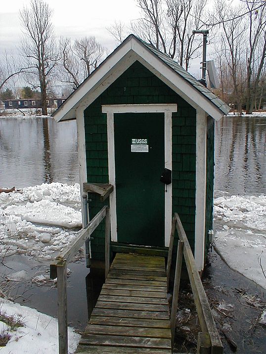
I was fortunate. Upstream from our home there are two river gages maintained by the U.S. Geological Survey (USGS). Throughout the day I was able to track the rising river and see that, despite the terrible damage occurring upstream, in our area no flooding was anticipated.
The gages’ flood forecasting capability offered me comfort, but for many flood forecasting is a matter of life and death. In areas more heavily damaged than where I live the gages offered the first clue that downstream areas needed to brace for the worst. Emergency personnel and homeowners had an opportunity to mobilize before the most serious damage happened. A mere four hours notice of an impending flood, gives people enough time to empty important things from their basements and move their cars, reducing overall damage by 10%.
Stream gages measure the height and flow of rivers. In addition to flood forecasting, data from gages are used to calculate nutrient loading to Lake Champlain, assess conditions for paddlers and anglers, and document potential impacts from climate change. Gages have been critical in our efforts to understand pollution in Lake Champlain.
However, many of the stream gages in the Lake Champlain Basin are threatened by budget cuts and USGS will be forced to discontinue them unless funding can be found to keep them going. The USGS gaging program has always been supported with a combination of local and federal funding with one third of the funding from USGS and the other two-thirds scraped together from local partners. With bipartisan support Congress authorized USGS to pick up a larger portion of gaging costs through the National Stream Flow Information Program. Then they failed to allocate any money to that effort. Congress needs to appropriate money to the National Stream Flow Information Program so that continued operation of gages does not require flipping the couch cushions for spare change each year as we have been doing.
Each stream gage costs about $15,000 annually to run. These costs include replacing old equipment, checking on the gages during high water conditions to ensure continued operation, and analyzing and interpreting the data from the gages. If a gage has not been funded for five years USGS will completely remove it requiring rebuilding if future funding becomes available. Rebuilding costs $20-30,000 per gage.
A total of $264,310 is needed annually to fund the Lake Champlain Basin gages currently on the chopping block. Historically, funding had come through an earmark from Vermont Senator Patrick Leahy. When Congress did away with those sorts of earmarks in 2010, another funding source was needed. Two years ago, the USGS found funds to cover the costs of the gages. Following that, funding from the Lake Champlain Basin Program (whose money comes primarily through the Environmental Protection Agency) and USGS kept the stream gages running temporarily. The gages are currently being operated without funding under the assumption that money will be found, but if no funds are dedicated to the gages, USGS will discontinue them on March 1, 2012.
The gages slated for closure in the Champlain Basin have provided a long-term data set for the region. Two of the gages, on the Ausable and Winooski Rivers, have been providing data for over eighty years. The Boquet gage has operated for 73 years while those on the Great Chazy and Salmon Rivers have operated for 67 and 50 years respectively. Another eight gages have gathered data for over 20 years: on the New Haven, Little Otter, Lewis, and LaPlatte Rivers in Vermont and on the Little Chazy, Little Ausable, Mettawee Rivers and Putnam Creek in New York.. Also slated for closure is the Lake Champlain gage in Whitehall which has collected data for 14 years.
The problem is not restricted to the Champlain Valley. Across the country, hundreds of gaging stations face funding shortfalls or have already been closed. In the long term, failure to maintain these extensive data sets will impair our ability to detect water quality trends in the Lake Champlain Basin. In the short term, loss of gages means our flood prediction abilities will be compromised. Stream gages provide a fundamental early warning system that saves human lives and protects roads, bridges, and personal property. Ask Congress to fund the National Stream Flow Information Program to keep the system in place.
Lake Look is a monthly natural history column produced by the Lake Champlain Committee (LCC). Formed in 1963, LCC is the only bi-state organization solely dedicated to protecting Lake Champlain’s health and accessibility. LCC uses science-based advocacy, education, and collaborative action to protect and restore water quality, safeguard natural habitats, foster stewardship, and ensure recreational access.
Get involved by joining LCC using our website secure form (at www.lakechamplaincommittee.org), or mail your contribution (Lake Champlain Committee, 208 Flynn Avenue - BLDG 3 - STUDIO 3-F, Burlington, VT 05401), or contact us at (802) 658-1414, or lcc@lakechamplaincommittee.org for more information.
